![]()
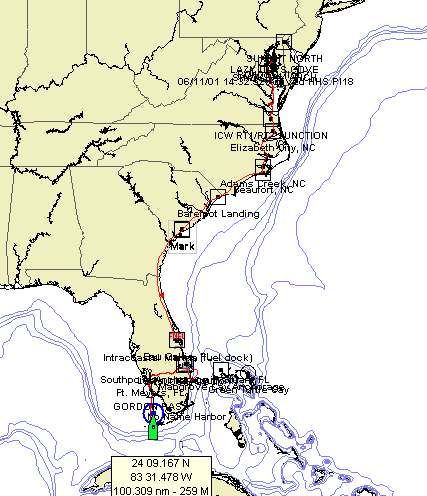
2001 saw us on the Chesapeake early in the year, then from October 2001 to July 2002 saw us moving south along the ICW to Key West in Florida. The plan was to get to the Bahamas, but weather and later circumstances changed all that.
This is an approximation of the route we took getting to Key West that I fudged using the navigation software. We should have been able to show our actual track but a recurring bug in the earlier version corrupted 3 of the earliest tracks. Hopefully this latest version solves that and next year we can show a proper track.
This is the log for 2001/2002 covering Rose Haven, MD to Key West, FL. The Log/Eng column shows the readings from the log and the engine hour meter at the end of the day. When we left Herrington Harbor South on 10/20/02, the log was probably 87 nm and the engine hour meter was around 25 hrs. Under the Fuel column, an entry indicates we bought fuel that day and in parenthesis is the cum fuel purchased. This is followed by the fuel burn rate for the last leg in gallons per hour and in parenthesis is the average fuel burn rate cumulated for the entire log. To sum it up, Goosebumps...
That's a lot of engine time and exactly what we should have expected considering it was all on the ICW. We cruise at about 2,800 rpm (the recommended 3,000 rpm just felt too fast). The tachometer uses the alternator for its input and (I think!) the tach was calibrated at the factory. In St. Augustine we changed alternators, installing a 75 amp BalMar to replace the 50 amp Hitachi that Westerbeke suppliesr. That completely upset the tachometer calibration and I had to readjust based upon where I thought the throttle lever was normally resting at cruise. You'll notice that our fuel consumption dropped off considerably after St. 'Gus (which I didn't notice at the time) and is probably because we're running at lower revs because of inaccurate tachometer calibration. Since the speed is at least close and the fuel consumption dropped almost 50%, I guess I'm OK with the way it worked out.
| Log/Eng |
Fuel (gal) |
Position |
Remarks |
|
| 11-Apr-2001 |
09.2 nm 04.3 hr |
38-57.616 N 76-29.015 W |
Took delivery at PCI dock. |
|
| 17-Apr-2001 |
26.4 nm 07.5 hr |
27.0 (0.0) |
38-43.405 N 76-32.494 W |
Herrington Harbor South in Rose Haven, MD. |
| 20-Oct-2001 |
120.7 nm 32.0 hr |
20.0 (20.0) 0.800 gph (0.800) |
38-20.370 N 76-28.119 W |
Solomon's Is., MD |
| 21-Oct-2001 |
164.0 nm 43.7 hr |
11.0 (31.0) 1.507 gph (0.960) |
37-48.147 N 76-18.763 W |
Mill Creek, Great Wicomico R., VA |
| 22-Oct-2001 |
210.0 nm 49.2 hr |
37-23.029 N 76-20.600 W |
East River, Mobjack Bay, VA |
|
| 23-Oct-2001 |
217.1 nm 57.6 hrs |
14.1 (45.1) 0.557 gph (0.783) |
37-18.201 N 76-27.216 W |
Severn R., VA (Severn R. Marina, 1 nite) |
| 24-Oct-2001 |
253.0 nm 65.6 hrs |
36-50.738 N 76-17.937 W |
Hospital Pt., Portsmouth, VA |
|
| 25-Oct-2001 |
302.6 nm 70.2 hrs |
36-44.431 N 76-20.691 W |
Deep Creek, VA |
|
| 26-Oct-2001 |
336.4 sm 79.4 hrs |
36-20.603 N 76-13.161 W |
Goat Is., Pasquotank R, NC |
|
| 27-Oct-2001 |
343.6 sm 81.7 hrs |
12.5 (57.6) 0.579 gph (0.705) |
36-18.002 N 76-12.706 W |
Elizabeth City, NC (Pelican Marina 2 nites) |
| 29-Oct-2001 |
397.6 sm 90.8 hrs |
35-40.540 N 76-05.931 W |
Tuckahoe Pt., NC |
|
| 30-Oct-2001 |
433.6 sm 96.5 hrs |
35-32.988 N 76-37.213 W |
Belhaven, NC (Robbs Marina & Boat Yard) |
|
| 31-Oct-2001 |
485.2 sm 104.9 hr |
34-55.946 N 76-38.786 W |
Adams Creek, NC |
|
| 01-Nov-2001 |
549.4 sm 115.6 hr |
18.0 (75.6) 0.720 gph (0.709) |
34-33.042 N 77-19.403 W |
Camp Lejeune, NC |
| 02-Nov-2001 |
591.2 sm 124.0 hr |
11.7 (87.3) 0.676 gph (0.704) |
34-12.465 N 77-46.946 W |
Wrightsville Beach, NC (confused wind in anchorage; need to anchors here) |
| 03-Nov-2001 |
654.2 sm 134.8 hr |
33-52.488 N 78-34.228 W |
Creek just inside the SC border |
|
| 04-Nov-2001 |
664.6 sm 137.9 hr |
11.8 (99.1) 0.959 gph (0.727) |
33-48.089 N 78-44.700 W |
Barefoot Landing, SC |
| 05-Nov-2001 |
686.9 sm 143.2 hr |
33-40.962 N 79-04.006 W |
Wacama R., ~1 mi. off ICW (2 nites at anchor in the cypress preserve) |
|
| 07-Nov-2001 |
697.0 sm 147.7 hr |
33-33.769 N 79-05.152 W |
Murrels Inlet, SC (Waccawache Marina, 10 nites) |
|
| 17-Nov-2001 |
736.2 sm 154.7 hr |
33-11.314 N 79-16.997 W |
Minim Cr, SC |
|
| 18-Nov-2001 |
789.9 sm 163.2 hr |
32-47.507 N 79-49.483 W |
Inlet Creek, SC |
|
| 19-Nov-2001 |
799.4 sm 166.5 hr |
17.1(116.2) 0.566 gph (0.698) |
32-46.893 N 79-57.467 W |
Charleston, SC (Ashley Marina, 5 nites) |
| 25-Nov-2001 |
883.4 sm 181.1 hr |
32-22.389 N 80-37.715 W |
Cowen Creek near Parris Is. MCRD (1-800-MARINES!) |
|
| 26-Nov-2001 |
932.3 sm 189.1 hr |
16.2(132.4) 0.717 gph (0.701) |
31-58.790 N 81-03.345 W |
Isle of Hope, GA |
| 27-Nov-2001 |
975.6 sm 196.3 hr |
31-36.081 N 81-13.047 W |
Wahoo River, GA |
|
| 28-Nov-2001 |
1,029.8 sm 205.1 hr |
13.8(146.2) 0.863 gph (0.713) |
31-09.964 N 81-24.899 W |
Golden Isles, GA (Golden Isles Marina, 3 nites) |
| 01-Dec-2001 |
1,069.1 sm 211.7 hr |
30-46.344 N 81-28.257 W |
Greyfield, GA on Cumberland Is. |
|
| 02-Dec-2001 |
1,128.6 sm 221.1 hr |
30-03.161 N 81-21.680 W |
Pine Is., FL |
|
| 03-Dec-2001 |
1,142.9 sm 224.0 hr |
14.0 (160.2) 0.741 gph (0.715) |
29-53.875 N 81-18.542 W |
St. Augustine, FL. (city marina & anchored, 27 nites) |
| 29-Dec-2001 |
1,183.3 sm 266.6 hr |
29-13.997 N 81-01.348 W |
Daytona B, FL |
|
| 30-Dec-2001 |
1,241.5 sm 275.7 hr |
Titusville, FL (Kennedy Pt. YC & Marina, 6 nites) |
||
| 05-Jan-2002 |
1,275.7 sm 282.7 hr |
24.3(184.5) 0.450 gph (0.664) |
28-05.243 N 80-35.264 W |
|
| 07-Jan-2002 |
1,318.9 sm 294.9 hr |
13.2(197.7) 0.781 gph (0.670) |
27-28.044 N 80-19.690 W |
Ft. Pierce, FL (Harbortown Marina, Berth H11, 11 nites) |
| 18-Jan-2002 |
1,319.3 sm 296.3 hr |
Faber Cove, Ft. Pierce, FL |
||
| 21-Jan-2002 |
(dead) 307.5 hr |
27-09.245 N 80-11.776 W |
Stuart, FL in Manatee Pocket |
|
| 22-Jan-2002 |
27-12.045 N 80-15.680 W |
Stuart, FL (Southpoint Anchorage mooring, 29 nites) |
||
| 20-Feb-2002 |
1,344.7 sm 355.6 hr |
26-45.625 N 80-02.589 W |
L. Worth Inlet, FL, marker R6 |
|
| 21-Feb-2002 |
1,210.8 nm 365.1 hr |
27-12.045 N 80-15.680 W |
L. Worth, out into Gulf Stream, back to St. Lucie Inlet, Stuart, FL (mooring, 61 nites) |
|
| 11-Mar-2002 |
367.0 hr 1,232.9 nm 400.7 hr |
27-12.045 N 80-15.680 W |
Refueled |
|
| 24-Apr-2002 |
1,232.9 nm 400.7 hr |
30.1(217.8) 0.417 gph (0.593) |
26-59.256 N 80-36.313 W |
Port Mayaca, FL |
| 25-Apr-2002 |
1,474.5 sm 411.5 hr |
5 gal from jug |
26-47.488 N 81-15.376 W |
1 mi W of Glades, FL |
| 26-Apr-2002 |
1,486.5 sm 415.6 hr |
26-46.128 N 81-26.299 W |
LaBelle, FL (city dock, 1 nite free) |
|
| 27-Apr-2002 |
1,524.3 sm 423.3 hr |
26-37.715 N 81-55.037 W |
Ft. Myers, FL (Paradise YC, 1 nite) |
|
| 03-May-2002 |
425.0 hr |
30.0(247.8) 0.517 gph (0.583) |
26-37.715 N 81-55.037 W |
Ft. Myers, FL (Paradise YC, 1 nite) Ft. Myers Yacht for bottom paint (ACP-50). 15 gal to new jugs |
| 04-May-2002 |
1,377.5 nm 437.5 hr |
26-05.449 N 81-47.932 W |
Gordon Pass, Naples, FL |
|
| 05-May-2002 |
1,387.8 nm 440.9 hr |
25-58.010 N 81-44.620 W |
Capri Pass, Marco, FL [Note: Celia broke her leg here] |
|
| 07-May-2002 |
1,429.1 nm 457.0 hr |
26-27.306 N 81-56.798 W |
Ft. Myers Beach, FL |
|
| 08-May-2002 |
1,444,4 nm 455.0 hr |
26-37.674 N 81-55.060 W |
Ft. Myers, FL (Paradise YC, 57 nites) [stayed while recovering from medical procedures] |
|
| 03-Jul-2002 |
1,458.3 nm 459.0 hr |
15.0(262.8) 0.441 gph (0.572) |
26-27.330 N 81-56.666 W |
Ft. Myers Beach, FL |
| 04-Jul-2002 |
1,492.5 nm 468.0 hr |
25-58.013 N 81-44.631 W |
Capri Pass, Marco, FL |
|
| 06-Jul-2002 |
1,577.2 nm 491.6 hr |
24-34.662 N 81-44.980 W |
Key West, FL (Sunset Marina; stay till after hurricane season) |
1) Where no marina is listed, we were anchored.
2) Some marina stops involved travel away from the boat
3) Drop in fuel consumption occurred with new alternator. We probably affected
tachometer calibration. Also we did a lot of battery charging at anchor which
uses less fuel.
![]()